The first 20 miles out of Ft. Nelson the road was in great shape. After that it narrows and the speed gets slower because you enter the mountains. They were also doing some road repair which just meant they were dumping gravel on the road. We were lucky getting through that section without losing a windshield.
We stopped along the road at the Tetsa River lodge for a cinnamon bun. They say that they are the cinnamon bun center of the galactic cluster. With a name like that we just had to try it. They were right. They were awesome. We had gotten one to go and then realized it was warm so we ate it right away.
 |
| We saw these billy goat looking things. |
 |
| We also this cow looking thing. |
Our plan for the day was to stop at Muncho Lake Provincial Park for the night. It wasn't far from Ft. Nelson so we got there early. It was cloudy and cool so we decided to move on.
I don't know if this lake is fed by glacial water but it kind of had that hue to it. As we were driving along we would see where all of this rock has been washed out of the mountains.
It was fascinating. Plan B was going to be a Provincial Park farther down the road. The Liard Hotsprings Provincial Park. They take reservations at that one which we didn't know and the campground was full. So on we went.
 |
| More cow looking things. |
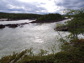
It was fine there. Two other campers were using that pull out also. We walked down to the rapids and that was spectacular. The river splits into 3 different channels at this point.
 |
| "Tango, my cellular phone doesn't work here. I don't like it." |
Critter count-3 stone sheep, 2 black bear, 1 moose, 1 whitetail deer and about 50 wood bison.
Watson Lake is known for its sign post forest. Started by a lonely G.I. in 1942, it has grown to over 88,000 signs.
People started posting their own signs and it has grown and grown. People use almost anything and nail it up there. There were frisbees, shoes, tupperware lids, almost anything they could find. If you are up here, look for ours. I bet you can't find it, and if you do I will buy you a beer. Just not in Canada because I can't afford Canadian beer. $45 a case, really? Something else I can't afford. Propane. I paid $9 in Shelby, MT for a 20 lb. tank. It was $26 here. Also diesel. I just did the math and we filled up at $5.33 a gallon. The farther north you get the more it costs. Yikes. But the amazing scenery is worth it! It's also getting us ready for California and Disney prices.
We left the town of Watson Lake and drove out to Watson Lake to a government campground. $12 is more to our liking. Free firewood here also. Gotta love that.
We are making our way north a little faster than we thought we would so we are looking into some side trips coming up. So stay tuned for that.
This is a picture of Watson Lake. Everyday we are threatened by hit and miss showers. Usually they don't miss though.
Critter count-2 wood bison and 2 porkypines(porcupines).
Now I just want to leave you with a couple of photos of how it feels for us to be up here on this trip.
"Gladys! I feel like the Joker. I can't stop smiling."
I am just going to post these as I can because cell service is very spotty now. I have a chromebook and you can't even just type a document without some kind of internet service. Our Wifi Jetpack doesn't work in Canada so I have to use my phone as a Wifi hotspot for my computer. It works so far as long as we have cell service.


Looks gorgeous. Watch out for those bear looking things!
ReplyDeleteIn the Milepost book it says to watch out for bears eating veg in the ditch. Haven't seen too many of those.
DeleteDid you see our sign?!?!? We will look for yours when we head up there next year. We too ran across a lot of the same people on the road, it is pretty funny how you see the same people all the time.
ReplyDeleteNo we did not see yours. It was hidden pretty well. Was it the one from Beaver Wisconsin?
DeleteLove following your trip north. Thought we'd do it someday, still, you never know :)
ReplyDeleteYou may need a vacation.
Delete